

As was widely reported in the media, at around 10pm last Saturday night, a “sinkhole” opened up at a beachfront campground on the Inskip peninsular.
The thing is, it almost certainly wasn’t a sinkhole.
Unanticipated ground collapses occur around the world from time to time, and these generally get labelled “sinkholes”, for want a more appropriate term. Yet “sinkhole” is poorly defined and often misused, generally referring to some type of geological phenomenon that causes localised ground surface collapse.
In its strict sense, a sinkhole occurs when there is movement of surface soil or rock downward to fill a cavity in the ground below it. Thankfully, open underground cavities are not so common in nature, and are limited to a few characteristic geological settings.
The classic manifestation of sinkholes is in karstic geological environments, such as the Nullabor Plains. These are where the percolation of groundwaters through limestones and dolomites over geological timescales causes them to dissolve, leading to the formation of underground cave systems.
Where the span of the caves becomes too great, or the overlying roof rocks are too thin to support themselves, these may collapse. This produces the stereotypical sinkholes such as those known from Guatemala, Florida, Louisiana, and parts of China.
Sinkholes can also arise from anthropogenic activity, such as mining and engineering works. Poorly backfilled or capped mine shafts may subside if the backfill collapses or is washed to deeper levels in the mine by inflowing water, such as occurred in the case of the Swansea “sinkhole” near Newcastle, New South Wales, in 2014.
Shallow tunnels can also collapse, leading to a hole or depression forming in the ground above. Small sinkholes can also occur above breaks in unpressurised wastewater pipes if soil from around the pipes is able to collapse into the pipe and be carried away with the flowing water.
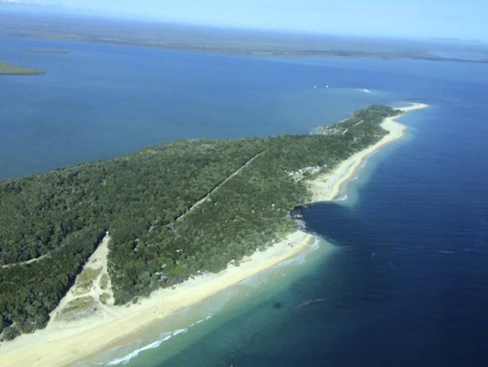
Sandy straight
So how does any of this explain the Inskip beach “sinkhole”? Well, it doesn’t. And from the photographs and available geological information, it seems like the event at Inskip beach is not a sinkhole at all.
The Inskip beach area is not undermined, and not known for the occurrence of limestones in its bedrock. So its very unlikely that the missing sand has been swallowed into some deep hole in the sea floor.
To understand the likely reasons behind the Inskip event, it is necessary to understand the geological setting of the Inskip peninsular. For millions of years, the coastal river systems of New South Wales have generated vast quantities of clean quartz sand, which have been delivered to the ocean.
Some of this sand is pushed up to create some of the best sandy beaches in the world. Meanwhile, the excess (and there is a lot of it) is swept northward along the coast by ocean currents until it reaches a place where it can be deposited.
Through a complex combination of ocean current, ocean swell, coastal morphology and bathymetric factors, Fraser Island in Queensland – the largest sand island in the world – is the repository for much of this excess sand.
The situation is complicated by the Mary River, which discharges into the ocean at the same place. This means that Fraser Island is separated from the mainland by a channel, which allows the Mary River to discharge to the ocean, mainly northward through Hervey Bay.
The southern end of this channel, the “Great Sandy Straight”, forms an estuary at Tin Can Bay, which accommodates tidal flows inward and outward between the Inskip peninsular and Fraser Island. And this is the site of recent collapse event.
Slippery sand
Tidal channels are dynamic environments, carrying sand backward and forward on a daily basis, depositing sand, and then scouring it out again when the channel becomes constricted. If sand is spilled into a pile, it forms a slope at a characteristic angle, referred to as the angle of repose.
If a slope is made any steeper than this, it is potentially unstable and prone to collapse. Sands deposited to form the submerged banks of the channel are flatter than, or equal to, the angle of repose and exist in a stable condition.
However, if the sandy banks of the channel are steepened through erosion in the bottom of the channel, then the over-steep submerged slope may become unstable, resulting in a submarine landslide. Such a slide, initiated at the toe of the slope, will effectively see the slope unravel, with slices of the slope progressively slumping into the space created by the slumping of the slice below.
This mechanism fits well with the situation at Inskip beach, both in terms of the geomorphological conditions and the reported characteristics of the beach collapse.
Will there be more events like this? At some time in the future, most likely. But when, where and how big are all questions that are difficult to quantify without site specific geotechnical and hydromorphological data. Coastal environments are dynamic, restless environments, and the risks of sudden changes are small, but ever-present.