The Ethereal Beauty of Kauai’s Alakai Swamp Trail
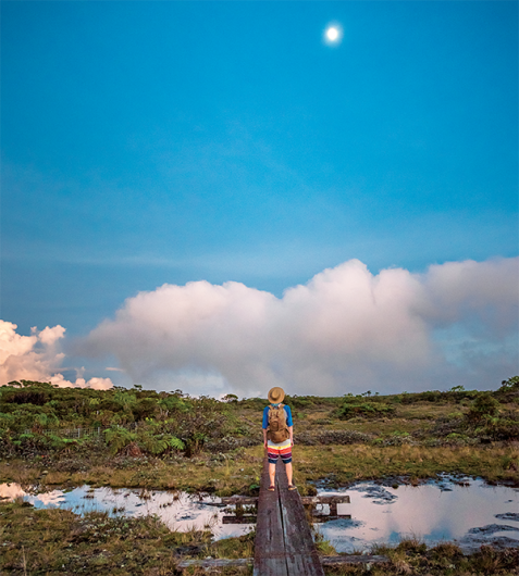
About three and a half miles of this trail meanders along a boardwalk, a portion of which cuts through a boggy swamp on a plateau above the Napali Coast.
The wood-burning fireplace in the dingy, barely insulated state cabin at the Lodge at Kokee on Kauai wasn’t enough to keep me warm that first night, so I had donned everything I had in my backpack: a long-sleeved shirt, a thin hoodie, two pairs of socks and a rain jacket.
It worked out, since that’s what I wound up wearing on our first hiking adventure in the state park the next morning.
It was late March, and we were standing at 4,000 feet above sea level in a dark, empty parking lot at a lookout above Kalalau Valley. There wasn’t much to see at 6:30 a.m., and it was cold. Like, 50 degrees cold. I wish I had listened to my husband, who had packed long underwear for the trip.

Photo: Mallory Roe
We were in Kokee, north of Waimea Canyon on Kauai’s rugged west side, for my 40th birthday. The plan was to escape the traffic and crowds of Honolulu by holing up at this state park, which sprawls over 4,345 acres and boasts about 45 miles of hiking trails through native forests and along canyon rims. The fact that there was no cell reception or Wi-Fi was another bonus.
It was just a weekend jaunt, so we packed as lightly as possible, filling our backpacks with hiking essentials like binoculars for birding, camera gear, granola bars, Aleve, a first aid kit and several liters of water.
On our must-hike list: the Alakai Swamp Trail, a roughly 7-mile hike—roundtrip and depending on where you start—through lush forests. About three and a half miles of this trail, which includes the Pihea Summit Trail that starts at the Pu‘u o Kila Lookout where we had parked our rental car, meanders along a boardwalk, a portion of which cuts through a boggy swamp on a plateau above the Napali Coast.
That’s really why we were here: to walk through this unique wet forest—an ecosystem zone described as “montane”—that is found nowhere else on Kauai. (There are only two other accessible bogs like this in Hawaii: one on Oahu and another on Molokai.)
The swamp is located on elevated flatlands near Mount Waialeale, one of the wettest spots on the planet. Because of the soggy soil and high winds here, the vegetation, including ohia and olapa trees, are stunted, some not even rising past my shoulders.
This bog is a strange and mysterious place, one that has been revered by Hawaiians for centuries. In fact, the swamp is mentioned in a chant that honors Waialeale: “[Kauai’s] strength radiates in awful splendor from the Alakai.”
Even Queen Emma, who returned to Kauai in 1870, to recuperate after the deaths of her only son and husband, made the difficult trek on horseback to the legendary swamp. The setting so entranced the queen, wrote Edward Joesting in Kauai: The Separate Kingdom (UH Press, 1984), she bid the dancers and musicians who traveled with her to perform here before pressing on.
I was enchanted.
We started the hike just beyond the lookout at the trailhead for the Pihea Summit Trail, an easy stroll along an eroded dirt road that follows the rim of Kalalau Valley, through a native ohia forest with aalii shrubs, to the peak named Pihea. Along the way are breathtaking views of the lush, amphitheater-headed Kalalau Valley about 4,000 feet below.
We had lucked out, too. While this area gets about 70 inches of rainfall annually, much of it concentrated between October and May, the path was relatively dry and the temperatures quickly warmed up to the point where I could shed my outer layers and hike with just a tank top on.

Photo: Catherine Toth Fox
We wandered along a few up-and-down sections lined with the green fronds of the amau ferns, a familiar sight I’d also encountered along the Halemaumau Trail in Hawaii Volcanoes National Park on Hawaii Island. After a few miles, we reached a signed junction that pointed to the summit of Pihea (elevation 4,284 feet), which is surrounded by the fluttering olapa trees, puahanui shrubs and views of Kalalau Valley. To the right was the trail that led to the swamp.
It didn’t take too long for us to reach the boardwalk, a system of redwood planks outfitted with chicken wire to provide traction. The state began building the boardwalk in 1991 to minimize the impact of hikers on this pristine environment, which boasts more than 50 different species of native plants. In some areas, the trail was getting as wide as 30 feet, with hikers trampling native plants and shrubs. And many of them would get lost wandering through the forest and swamp, unable to find their way out. It took nearly 10 years to finish construction of the boardwalk, which allows the more than 600 people who hike the trail every month to enjoy this unique ecosystem without damaging it or getting lost.
This was my favorite part of the trail, strolling through ohia trees and hapuu ferns and listening to the chattering of endangered birds such as the white-rumped apapane and the green amakihi (both Hawaiian honeycreepers). Armed with my high-power binoculars, I caught glimpses of these charming little birds, along with the curious elepaio (monarch flycatcher) and red-breasted iiwi (Hawaiian honeycreeper).
We weren’t lucky enough, though, to spot the critically endangered puaiohi (small Kauai thrush), which is found here and only here. In fact, 75 percent of its breeding population occurs in just 4 square miles of forest. This state-designated wilderness preserve has already recently lost the Kauai oo (Hawaiian honeyeater). It would be a shame to lose the puaiohi, too.
About halfway to the swamp, we reached a series of around 200 steep, wooden stairs that took us lower and lower into the forest, past the native lobelia oha wai with its curved purple and white flowers, down to the Kawaikoi Stream. We crossed the tributary and made our way up the ridge toward the swamp.
This part of the trail followed an old telephone line put up by the U.S. Army’s Signal Corps during World War II. Most of the poles have been cut down at the base or have fallen over, adding to the strangeness of this place.
And it’s really otherworldly.

Photo: Mallory Roe
There’s a mist that settled over the expansive bog, with wispy clouds swirling around you. We walked in silence along the boardwalk through the wet forest, over thick gray clay and among dwarfed trees, toward the Kilohana Lookout, a small platform perched 4,030 feet above Kauai’s northwest shore. It took us about five hours to reach it. (Birding was a bit distracting!) We stopped for lunch and breathed in the stunning views of Wainiha Valley and the crescent-shaped Hanalei Bay dotted with whitecaps.
As we sat there, marveling at the clear vista that’s usually shrouded in clouds, a friendly ‘elepaio hopped on a branch nearby and tilted its little brown head at us. Before I could grab my camera, the bird disappeared, flying down the sheer cliffs and out of sight.
Though I missed the chance to capture an image of that rare moment, my memory of that little bird—and everything else we experienced here—was really enough.
Pihea Trail and Alakai Swamp Trail to Kilohana Lookout, Kokee State Park, end of Kokee Rd., Kauai. kokee.org, hawaiistateparks.org.