In war-torn countries it can be challenging for humanitarian groups to quantify deaths and damage accurately. But science can help them get a little closer.
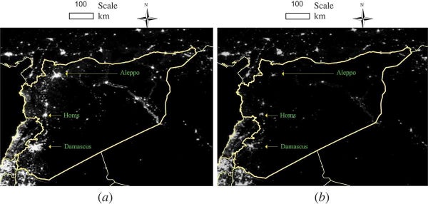
Using satellite imagery of Syria, Xi Li, a visiting scholar at the University of Maryland, College Park, found that the country is now 83 percent darker at night than it was at the beginning of the civil war four years ago. The analysis updates a study published in the International Journal of Remote Sensing in September 2014, which found light loss was about 74 percent from March 2011 to February 2014. The maps here show darkness levels in March 2011 (a) and February 2014 (b).
Li says the most affected regions are areas controlled by the Islamic State (aka ISIS or ISIL) in Aleppo, Idlib and Raqqah, where light loss was 96 percent or higher. Government-controlled Damascus was relatively better, he says, but lost illumination was still about 35 percent. The increased darkness, caused by reduced fuel consumption, is a sign that people have fled a region, died there or, at the least, lost access to electricity and fuel because of destroyed infrastructure or power cutoffs. The images can therefore help to pinpoint places where conflict is the worst, because the darkness could signify that the area is not under control of any one group. Such stateless zones could also be exactly the ones holding the most risk for aid workers.
On supporting science journalism
If you're enjoying this article, consider supporting our award-winning journalism by subscribing. By purchasing a subscription you are helping to ensure the future of impactful stories about the discoveries and ideas shaping our world today.
Since the country’s civil war erupted in 2011 more than 220,000 people have died, 7.6 million have been displaced within Syria and another four million have fled the nation, according to the United Nations.
“Compared to the fragmented reports from media, satellite images—especially the night light image—can provide a whole picture of the war,” Li says. “We see this effort is successful in Syria. More attention has been paid by [the] international community on Syria due to our released images.”